Causes and remedies of flash floods
- Last Update : 03:16:14 pm, Tuesday, 27 August 2024
- / 947 Read Count
By Md. Zillur Rahaman
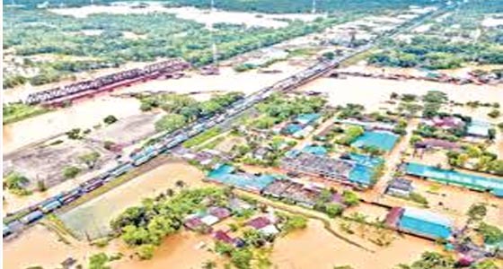
Heavy torrential rains in the Indian state of Tripura in recent days have caused severe flooding. It has been reported that seven people were killed and two others are missing. Due to floods, the authorities have opened the dam of Dumbur hydropower project in Tripura. As a result, 11 districts of Bangladesh have been submerged by water. Thirteen people have died and hundreds of thousands of people have been displaced.
Among the various natural disasters, floods are particularly significant, which hit our country more or less every year. Floods started in this country since 1954. Since then till 1998 about 32 major floods have hit, out of these 17 are mentioned as very dangerous. The most memorable floods in the history of Bangladesh occurred in 1970, 1991, 1988 and 1998. Especially in Sylhet region, significant floods occurred in 1999, 2004, 2007, 2018, 2019 and 2020. Moreover, floods recently held in Sylhet and Sunamganj regions in the first phase on May 29, 2024 and in the second phase from June 17. However, the 2022 flood is an exception, in the history of 122 years Sylhet and Sunamganj did not experience such a flood.
In this, communication with Sylhet by road, rail and air was cut off. Cherrapunji, India’s rainiest region in the world, received a record amount of rain during the extra heat. The water there is supposed to come directly to the Hoar of Bangladesh and mix and go to the sea through Bhairab or Meghna, but it is obstructed due to various reasons and enters all the districts of Sylhet division. Within a few days, 80 percent of the area of Sylhet division went under water and several northern districts were flooded.
Natural disasters do not always occur; rather, it comes through the creation of various human-made contexts and causes. Human-induced climate change and global warming are causing abnormally high temperatures, rising sea levels and heavy rainfall. Due to unplanned urbanization, filling of wetlands due to urbanization, reduction in navigability of rivers, diversion of rivers, obstruction of water flow by building roads in the middle of the river, non-dredging of rivers etc. As a result, it is flowing over the danger zone and is taking away crops, wealth, houses as well as people.
India cannot escape responsibility for Bangladesh floods at all. Rather unfortunately, Bangladesh is a victim of India’s water invasion. India is destroying Bangladesh bit by bit by building multiple dams including Farakka Dam, Tipaimukh Dam at the source of 54 rivers of Bangladesh, flouting international law and neighbor’s rights. During the rainy season, they kill us with water and in drought, they make Bangladesh a desert by blocking the water. Once there were 1200 rivers in this country, but now even 200 rivers are not active.
All dried up and turned into dead canals, many are untraceable. According to the record of 1971, 24 thousand kilometers of waterways have reduced to 6 thousand kilometers. A large amount of our arable land has been destroyed. Millions of people are affected by the lack of irrigation water. Excess salinity has reduced soil fertility and destroyed about 17 percent of the Sundarbans, the world’s largest mangrove. How much more damage has been done to us due to India’s one-sided policy, how many people keep an account of it!
Tripura Power Minister Ratan Lal Nath has denied the allegation that India opened the dam of Tripura’s Dumbur hydroelectric project without prior warning, causing severe floods in Bangladesh. He said, “I have opened the gate of Gomti Hydro Electric Project, this information is not correct. The propaganda that is being done about the opening of Dumbur gate is nothing but false propaganda”. In line with this, a written statement by the Ministry of External Affairs of India on August 22 (Thursday) said, “Flooding has occurred due to excessive rainfall in Tripura and neighboring areas. We have noticed complaints from Bangladesh that various areas of that country have been flooded due to the release of water from Dumbur Dam in Tripura. This is factually incorrect. Dumbur Dam is 120 km from the India Bangladesh border. The height of that dam is only 30 meters, the water that accumulates there cannot cause floods in Bangladesh.’
Prannoy Verma, India’s High Commissioner in Dhaka, spoke in the same tone. On Thursday (August 22) afternoon, the chief adviser of the interim government. The Indian High Commissioner went to his office ‘Jamuna’ to have a courtesy meeting with Dr. Muhammad Yunus. After the meeting, the Chief Adviser’s press secretary told journalists that the High Commissioner of India told the Chief Adviser that there has been a lot of rain in Tripura. Automatic release of water from the dam due to high water level. He said floods in Tripura are unpredictable which is causing problems for both the countries.
But Tripura’s media is telling a different story. Tripura media Borak Times reports that the authorities have opened the dam of the Dumbur Hydroelectric Project in Tripura for the first time since 1993. As a result, Hoar river flows through Tripura and enters Brahmanbaria district of Bangladesh, Dhalai river enters Moulvibazar, Muhuri river enters Feni district and Khoai river enters Sylhet. Many areas including agricultural land and residential areas are now submerged in water. Thousands of residents have been evacuated.
Tripura Revenue Secretary Brijesh Pandey told the media that due to heavy rains, severe floods have occurred in South Tripura and Gomti districts of the state. On Tuesday (August 20), he said, in the last 24 hours, 375.8 millimeters of rain was recorded in Bagafa, 324.4 millimeters in Belonia and 307.14 millimeters in Amarpur. One of the dam’s three gates was opened as of 8:35 a.m. local time on Wednesday (August 21). District Magistrate of Khowai Chandni Chandran said that two sub-divisions of the district have been severely affected as the water of Khowai River has crossed the danger level. He advised local residents to avoid fishing near rivers and stay away from landslide-prone areas.
Moreover, Tripura’s Gomti District Magistrate said on his official social media account that the water level of Gomti River may rise further. A vital source of water for both irrigation and hydropower generation in the Dumbur Hydroelectric Project. In the same situation, Dumbur Dam was last opened in 1993. After the lapse of 31 years, the Indian authorities have opened the dam again. However, the Indian Meteorological Department (IMD) said on Tuesday (August 20) that heavy torrential rains may continue in Tripura for two more days. IMD mentioned that the continuous rainfall is due to the influence of low pressure in the central and neighboring areas of Bangladesh.
We need to take some effective measures to prevent flash floods. Such as 1) patience in any difficult situation and persevere with strong courage, 2) stand by the side of the displaced people as much as possible and take up the process of their immediate rehabilitation, 3) how to prevent climate change and global warming, nationally and internationally. Appropriate action should be taken, 4) effective measures should be taken to increase the navigability of Bangladesh’s rivers and maintain it, 5) effective measures should be taken to stop water encroachment by India.
Bangladesh as a downstream country, as the source of significant rivers is outside the borders of the country, should take such a constructive initiative with the neighboring country India to keep the normal flow of the same rivers, so that it is effective and fruitfulmust close. There is no way to remedy the natural causes of floods in Bangladesh, such as the geographical location of the region, hill slopes from upstream, heavy rains. However, keeping these issues in mind, we have to find a way to deal with floods in this region.
First of all, it is necessary to ensure that the mountain runoff or heavy rain water coming from upstream is drained as much and as quickly as possible. For this reason, surveying the bottom of the rivers in the region and dredging the necessary places to increase the water flow capacity of the rivers, increasing the width of the river by removing all illegal encroachments on the two banks of the rivers, unplanned damming in the river and unplanned extraction of stones and sand from the river should be prevented, along with haor.
The connection of the rivers should be ensured, settlement and unplanned urbanization should be stopped in the natural floodplains of the river banks, reservoirs, drains, ponds should be stopped for temporary retention of rainwater and they should be conserved. In short, taking into account the public suffering and damage caused by the recent severe floods in the region, all technical and administrative steps should be taken to deal with such floods in the future.
The writer is a, Banker and Columnist